Old Brunswick Town-Fort Anderson, a site deeply shaped by American colonial history, is a true “hidden gem,” said Christos Darras, a graduate student at East Carolina University (ECU). For Darras, who is pursuing his degree in Maritime Studies, it is also the site for his graduate thesis. His current project might just help to answer some questions about the area’s true importance in colonial history.
Darras, who attended ECU’s Field School earlier in the summer, was offered an internship with the Friends of Old Brunswick Town/Fort Anderson. He began researching a former colonial wharf that is no longer truly “accessible” to the public, but is hidden from view. It is Darras’ goal to bring new life to this wharf in a way the public may not immediately expect.
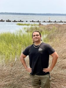 As part of his project and internship, Darras is working on developing a digital reconstruction of the wharf, known as Moore’s Wharf or Wharf 01, to aid in the understanding of why that wharf specifically carries importance and how it may have been used in the colonial era.
The land on which Old Brunswick Town-Fort Anderson sits was once owned by the renowned colonial Colonel Maurice Moore and his brother “King” Roger Moore. It was known in the colonial ages due to the depth of its water, which allowed for easy passage of larger, goods-laden merchant ships. This enabled Brunswick Town to become a world-class port and the fourteenth busiest in all of the colonies by the mid-1700s.
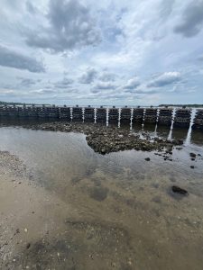
What was once a major port for lumber, pitch, tar, and turpentine, is now a historical site offering visitors a glimpse of early life in the American colonies. However, part of that glimpse might require goggles and a swimsuit, given that part of the site — including Moore’s Wharf — is now submerged under the surface of the water.
Darras describes his ambitious undertaking as a “project of understanding,” as it will allow him and the public to discover how the wharf was constructed, why it was positioned where it was, and ultimately why the wharf was important in colonial times.
Currently, Darras estimates that he is “modestly halfway” complete with the project, stating that he has already created some concept art using artificial intelligence (AI). Though he has used AI in the initial designs, Darras maintains that it is just “a supportive tool,” and that the only way to actually know how the wharf was shaped is through “more archaeological research and survey.”
The site itself is marked with wave attenuators, which were installed in 2019. These help to absorb shock from wake energy. While the attenuators do not fully absorb the waves, they aid in protecting the site from erosion due to the marsh-like environment.
Though this project has been very successful thus far, Darras said that his biggest challenge to date has been the digital reconstruction software. He explained that the software works, but that his current setup is not as compatible, compared to if he was creating this digital model on ECU’s campus.
 Even through the challenges, Darras loves interacting with the public because “people want to know,” he explained. “Then they tell their friends who then become interested,” he went on to say. He views one of his biggest successes as being able to reach out to the community, as it feels as though what he is doing is actually important.
Jim McKee, site director for Old Brunswick Town-Fort Anderson, described this project as “another piece of the puzzle.” He explained that there are not really any true visuals of how Old Brunswick Town-Fort Anderson was used in colonial times, and that “it is like building a jigsaw puzzle with three-quarters of the pieces missing.”
While Moore’s Wharf is the focus of Darras’ project, McKee clarified that this wharf is not the only one. William Dry’s Wharf, which began washing up in 2008, has been systematically mapped by McKee. The two or three more wharfs that lie to the south are additional projects of ECU’s Field School.
McKee said that everyone has different visions of what a wharf looks like now, but that this project will allow for a representation of what a wharf looked like 250 years ago. McKee is helping to support the project by providing technical information from William Dry’s Wharf due to its similarity to Moore’s Wharf.
In the near future, Darras intends to meet with his advisor to plan his next steps regarding data and models. You can follow along with the progression of his project at Friends of Brunswick Town/Fort Anderson on Facebook.